

The largest coral reef in the world stretching 1429 miles (2300 km) along the coast of Queensland in the Coral Sea. Of the many hundreds of varieties of coral growing on the reef, the predominant varieties are "staghorn", "brain" and "table", which are all pretty aptly named.

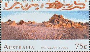
The Willandra Lakes Region World Heritage Area encompasses all 19 lakes of the Willandra Lakes system. It includes much of Mungo National Park and a larger area of leasehold grazing country. Parts of Mungo National Park which were added to the park after the 1981 listing are not included in the World Heritage area.
 The Tasmanian Wilderness World Heritage Area
covers approximately 20% of Tasmania. Much of the area is still
pristine wilderness and contains plants and animals found no where
else in the world.
The Tasmanian Wilderness World Heritage Area
covers approximately 20% of Tasmania. Much of the area is still
pristine wilderness and contains plants and animals found no where
else in the world.
The Overland Track is a spectacular 80km walk which traverses rainforest, button grass plains, and Tasmania's high country. It connects the two eponymous features in the Cradle Mountain-Lake St Clair National Park. Other serious bushwalking tracks include the South Coast Track and the route to Frenchman's Cap.
It is possible to take a leisurely boat trip along the Gordon River and view the surrounding rainforest. The dominant trees are Myrtle, Sassafras, Leatherwood and the Huon Pine. The Huon pine (Lagarostrobus franklinii) is the second longest lived organism in the world after the Californian bristlecone pine, reaching ages in excess of 3000 years.
Marakoopa and King Solomons Caves are located in the northern part of the Tasmanian Wilderness World Heritage Area. The former is a "wet" cave with two distinct rivers. Inside can be found lots of cool formations in the shape of straws, curtains, rashers of bacon, lily pads, etc. There are also glow worms. King Solomons Cave is a "dry" cave. This does not mean it is dry, just that no river runs through it.
 We made a quick hop to Lord Howe Island in April, 1995,
during our Year Down Under.
This tiny island is 11km long (less than 7 miles) and about 2km wide,
but it has the southernmost coral reef in the world and some of the
world's rarest flora, birds, and marine life.
We made a quick hop to Lord Howe Island in April, 1995,
during our Year Down Under.
This tiny island is 11km long (less than 7 miles) and about 2km wide,
but it has the southernmost coral reef in the world and some of the
world's rarest flora, birds, and marine life.

(25.347 S 131.037 E) -- satellite image
The immense rock formation of Uluru is one of the world's most famous monoliths. It is 9.4 kilometers in circumference and rises 340 meters above the plain. William Gosse was the first European to sight Uluru in 1873 and named it Ayers Rock.
The site has great cultural significance for the Aboriginal people, who believe it played an important role in their Dreamtime. The sheltered caves and overhangs around the base of the rock have served as canvas to hundreds of generations of native artists. The listing also includes "the Olgas" a range of enormous rock domes 36 km (22 miles) to the west. These are called Kata Tjuta by the Aboriginal People which means "many heads."

Formerly called the Australian Central Eastern Rainforest Reserves, this World Heritage Listing is composed of several rainforest groups and over forty sites located on the east coast in New South Wales and Queensland. The great diversity of microclimates within the rainforests supports a large range of plant and animal species. Over 350 trees and shrub species as well as a diverse animal population, including 37 species of bats, are found in these rainforests.
Rainforest sections include:
Australia has one of the oldest landscapes on the planet. It includes 'living fossils' whose origins date back hundreds of millions of years. These biological treasures include a botanical dinosaur - the Wollemi Pine - recently discovered in the Blue Mountains of New South Wales.

Australia's Wet Tropics is a band of tropical rainforest and associated vegetation that runs along the east coast from Townsville to Cooktown. In recognition of its scenic beauty and biological importance, this region was World Heritage listed in 1988.

Fraser Island, situated adjacent to Hervey Bay, Queensland is the largest sand island in the world. It was named after shipwreck victim Eliza Fraser. The island is known as K'gari to its Aboriginal people, the Butchulla. The island was formed during the ice age when the prevailing winds transported the vast quantities of sand from New South Wales and deposited it along the coast of Queensland. Multiple layers of sand deposits which make up the island's massive dune system provide a geological record of climatic and sea level changes over the past 700,000 years.

Riversleigh Fossil Field is the paleontological find of the century! Naracoorte is a separate fossil site 2,000km away. Finds include the fossil remains of giant pythons (Monty pythonoides), carnivorous kangaroos, marsupial lions and huge flightless 'thunder birds'. And, let's not forget the Thingodont.

Macquarie Island is a small oceanic island in the Southern Ocean approximately halfway between Australia and the Antarctic continent. It is 34 km long x 5 km wide with a wide variety of wild life.

The area is called Blue Mountains because when atmospheric temperature rises, the essential oil of various eucalyptus species evaporates and disperse into the air. Thus, the reflected landscape from the mountains seems bluish to human eyes.

Located in the remote East Kimberley region of Western Australia, Purnululu is a mispronounced word for the area around the Bungle Bungle Range (Bullmanlulu). It possesses unique examples of cone karst that have eroded over a period of 20 million years.
Located in Melbourne, the Royal Exhibition building was built for the great international exhibitions of 1880 and 1888. Designed by Joseph Reed, the building is constructed of brick and timber, steel and slate. It combines elements from the Byzantine, Romanesque, Lombardic and Italian Renaissance styles.


The property includes a selection of 11 penal sites, among the thousands established by the British Empire on Australian soil in the 18th and 19th centuries.
The Ningaloo Coast is a 604,500 hectare marine and terrestrial property on the remote western coast of Australia. It includes one of the longest near-shore reefs in the world which is home to numerous marine species. The site also features subterranean water bodies with a substantial network of caves, conduits, and groundwater streams.
Located within the Country of the Gunditjmara, an Aboriginal nation in the southwest of Australia, the property includes the Budj Bim Volcano and Tae Rak (Lake Condah), as well as the Kurtonitj component, characterized by wetland swamps, and Tyrendarra in the south, an area of rocky ridges and large marshes. The Budj Bim lava flows, which connect these three components, have enabled the Gunditjmara to develop one of the largest and oldest aquaculture networks in the world.
Last updated: July 23, 2025